Photo : courtesy of the artist
Architecture of Network vs. Geometry of Separation
In the era of the extra-spatial and extra-temporal pervasiveness of the World Wide Web, we are still witnessing conflict between two world models: one based on the concept of the wall, intended as a device producing fragmentation, ghettoization, and division; and one based on the concept of the network, in reference to the development of a new kind of virtual space based on connection and space-time continuity. Therefore, on the one hand the world map is marked by deep lines of separation — physical boundaries, frontiers, walls, and so on. On the other hand, the world appears as a network of connected places in which the city has lost its role of accumulator. As a matter of fact, the demands of competitiveness and efficiency, combined with the logic of entrepreneurialism, make cities as if they are corporations in order to attract investments, while the need to occupy large areas requires enterprises to locate outside the city centre. Therefore cities are splitting into different clusters — each one with a specific activity — and public space is being concentrated in large arenas, wellness centres, and huge spaces for meetings, expositions, and fairs, following a model of physical isolation and virtual connection. Furthermore, a different kind of space is destined for social relations — the post-public space,2 2 - See Daniel Van der Velden, Katja Gretzinger, Matthijs Van Leeuwen, Matteo Poli, and Gon Zifroni, “Hybridity of the Post-Public Space,” Open 11 (2006): 112 — 23. in which the power of the Internet is concentrated. Post-public space is made up of private hubs of technological power, techno poles, headquarters of Internet giants, universities, and research centres where inventors live and work. This network can be visualized on a map that puts the above-mentioned hubs in relation to the air routes that connect them. Physical, political, ideological, and architectural borders — intended as places where conflict is materialized — act as a counterpart to this map by creating a sort of diagram of the world that shows places of exclusion. According to this perspective, the squares where clashes happen can also be considered to be points on the map.
These considerations can be visualized in a global map composed of points (connection nodes) and segments (separation lines) that unveil the conflict between the pervasiveness of the Internet and the existence of physical barriers. This diagram provides a figurative projection that resembles Alighiero Boetti’s artworks.3 3 - Alighiero Boetti’s planispheres and alphabets explore the issues of classification and the list mode as a system of writing. Moreover, these considerations outline a new paradigm in the study of social space, intended as both a physical and a digital space.
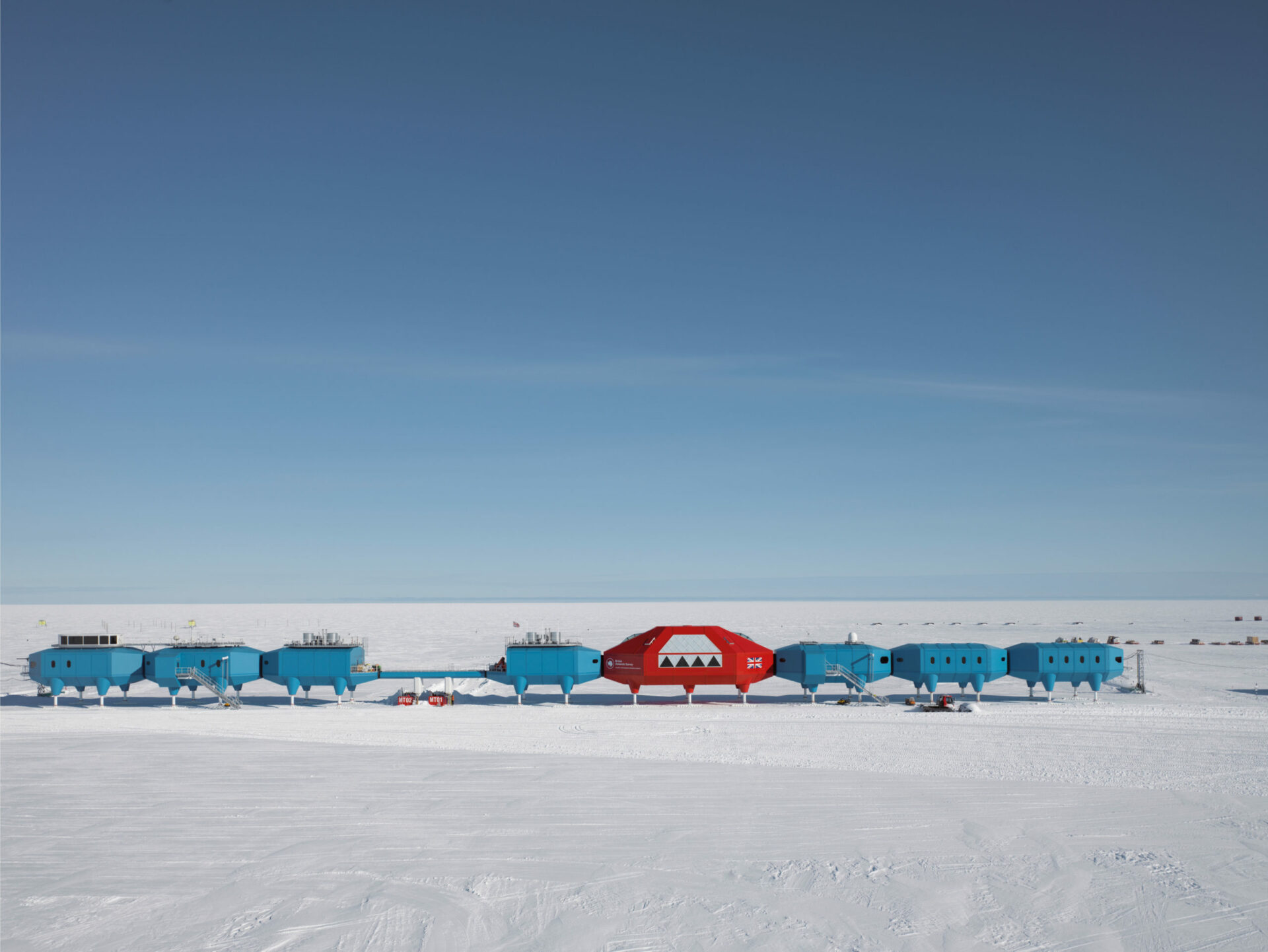
Halley VI British Antartic Research Station, 2005-2012.
Photo : © James Morris
In the second world model mentioned above, the globe is understood as a network, a system of continuous, fluid connections. This model was quickly established as the expression of a new democratic paradigm, thanks to the development of three components of the post-industrial era: globalization, the ICT economy, and the Internet.4 4 - See Lina Malfona, “La Critica in rete (Online Criticism)” in Riti di passaggio dell’architettura italiana contemporanea, ed. F. Purini and L. Malfona, special issue, Rassegna di Architettura e Urbanistica 133 (January 2011): 94 — 107. However, the relational model of the metropolis as a boundless territory, dominated by the interplay between real and virtual connections, still needs to be verified.
The birth of the World Wide Web introduced a change in the relationship between the city and its urban topography; in fact, the network of global financial centres, multinationals, industrial sites, computer-technology companies, and manufacturers of software and online products constitutes a global city, made up of fragments located on various transnational circuits. What is interesting is the nature of the nodes, the points at which the networks lose their properties by becoming the control centres of the reticular system. It is precisely in these real and virtual hubs that the conflict — implicit in architecture — between connection and separation may be grasped.
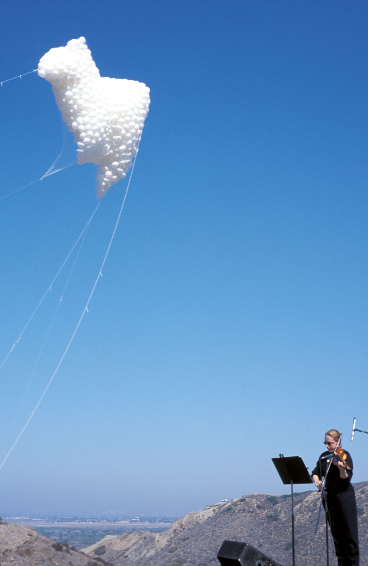
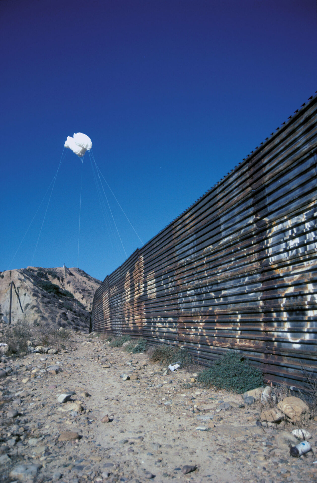
The Cloud, Valle del Matadar, Tijuana-San Diego, frontière U.S.A.-Mexico border, 2000.
Photo : courtesy of the artist
New architectural models seem to be introduced by the Internet: consider, for instance, the designs for the new headquarters of the Internet giants. The new centres where the power of the Internet is concentrated (San Francisco Bay and, in particular, Silicon Valley) offer the largest collection of buildings of this kind — are still under construction; projects and partial realizations seem to bring out new perspectives in designing spaces for the “creative class,”5 5 - See Richard Florida, L’ascesa della nuova classe creativa. Stile di vita, valori e professioni (Milan: Mondadori, 2003). but it is necessary to verify this position. The question is: Even if the Internet is a metaphor for freedom, democracy, and globalization, are the physical nodes of the Internet real spaces of freedom? Or, rather, are these centres of technological control and power a kind of self-referential stronghold? On closer inspection, the main centres related to production and consumption of the Internet are materialized as a reticular system of hubs of technological power but also an example of fortified areas. Therefore, the network of the main research institutes, technopoles, and worldwide centres of knowledge production related to the Internet could be intended as the realization of a sort of neo-colonialist thinking, if we take into account Manfredo Tafuri’s theories about the technocratic aspects of the American economy.6 6 - See Manfredo Tafuri, “Lavoro intellettuale e sviluppo capitalistico,” Contropiano 2 (1970): 241 — 81. Right now, these building projects are moving from interior designers’ offices to those of world-renowned architects. Frank Gehry, for instance, is currently designing the new campus for social media giant Facebook, which claims that it will be the largest open-plan office in the world, and Foster + Partners is designing Apple’s new campus, which looks like a whimsical flying saucer.
In the second model, the world is understood as a cretto, marked by thick, hard-to-demolish walls; a world carved up by real and virtual barriers, boundaries, and customs. The lines of separation display many configurations and typologies.7 7 - See Claude Quétel, Muri (Turin: Bollati Boringhieri, 2013). Among them are physical boundaries that are causes of conflict, such as the Ussuri river, on the border between China and Russia; and places of exclusion and contended borders, such as that between North and South Korea and the Green Line in Cyprus, mentioned by Michalis Pierìs in his collection of poems Metamorphoses of Cities. In this category are also public spaces where political clashes occur, such as Tahrir Square in Cairo; forbidden places such as military areas; and walls with symbolic meaning. Consider also ideological barriers, which can operate as walls (think of Chinese censorship), segregation enclosures such as gated communities, and city walls such as the ancient inhabitable Aurelian Walls in Rome.
Many artists work on projects aimed at sensing the signs of a possible overturning of spaces of separation. There are situations in which people form alliances with designers in an attempt to transform these spaces into places of inclusion. This happened in a village in the vicinity of Tel Aviv — filmed by Amos Gitai in the movie Ana Rabia (2013) — a boundary along which different, yet communicating, identities live together. Architects, artists, and photographers — such as Eyal Weizman,8 8 - See Eyal Weizman, A Civilian Occupation: The Politics of Israeli Architecture (London and New York: Verso Books, 2003). Alfredo Jaar, Teddy Cruz, Bansky, Guy Delisle, Fred Lonidier, and Josef Koudelka — have pitted their skills against well-known boundaries: from the wall between Mexico and the United States in Tijuana, to the concrete wall in the West Bank between Israel and Palestine that is more than seven hundred kilometres long.
Alfredo Jaar, through his work as both an architect and an artist, has been exemplary in denouncing the military measures designed to prevent immigrant workers from crossing borders. In fact, although the power of globalization has invalidated the very concept of a boundary, people still die simply trying to cross borders between two countries. Jaar’s installation The Cloud (2000) is an ephemeral monument in memory of those who lost their lives trying to cross the border at Tijuana.
Activist Fred Lonidier has also investigated the Tijuana wall by framing surveillance structures, unruly topographies, and migrants’ and workers’ crossings. In particular, he participated in the exhibition inSite_05 San Diego/Tijuana transborder mobile archive project (2005), organized by Ute Meta Bauer and curated by Osvaldo Sanchez. The task of the Transborder Archive was to form connections among activists, practitioners, and researchers in San Diego and Tijuana, on both sides of the border, by creating an exchange between their respective archives. However, the project also made these works known to various audiences and visitors: mobile units held events, discussions, and film screenings in the locations that they visited. The stationary exhibitions covered such topics as work, migration, human rights, and questions of identity and youth culture in the border region, through a combination of texts, books, postcards, photographs, films, videos, and online resources. According to Sanchez, the Transborder Archive served to make the structural similarities and specific differences of border regions more visible.
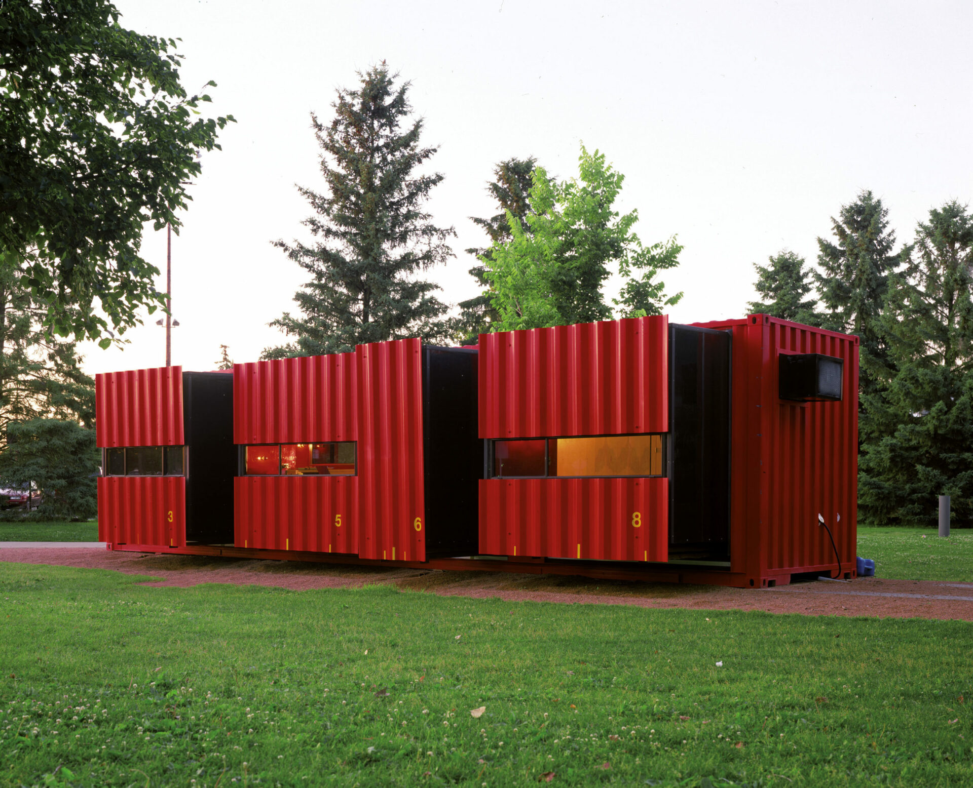
Mobile Dwelling Unit, 2003.
Photo : courtesy of Walker Art Center, Minneapolis
Without a doubt, the global city is the playground where a new paradigm is emerging for designing public spaces beyond the piazza. According to jurist Stefano Rodotà, who wrote the book Tecnopolitica,9 9 - Stefano Rodotà, Tecnopolitica (Rome and Bari: Laterza, 1997). the process started with Marshall McLuhan’s “global village,” which introduced a strong relationship between the virtual world and the urban space. Then, new urban metaphors, such as the technological agora,10 10 - See Simon Nora and Alain Minc, L’informatisation de la société (Paris: Seuil, 1978). the telematics square, and the virtual city, proposed a kind of correspondence between the two terms. Moreover, the new world of global communications has been inspired by both the spatial and the political organization of the city; in fact, the term agora refers to a model of direct democracy.
Among the analogies for digital and real space, the metaphor of the e-highway, which allows for navigation on the Internet, introduces a new model of nomadism, quite remote from the concept of the global village. It conveys the idea of an endless trip without a landing place. In the field of the arts, this concept can be found in the latest developments of mobile architecture, which conceives of buildings as innovative, adaptable, removable, and easily transportable structures. Think of the recent creations of Atelier Bow-Wow (such as the mobile restaurant White Limousine Yatai, 2003), Hugh Broughton (Halley VI, the scientific research station in Antarctica, 2005) and LOT-EK (MDU, Mobile Dwelling Unit, 2003). Furthermore, architectures for emergency facilities, cockpits, and inhabitable cars, space stations, and temporary shelters display a new dynamic idea of dwelling, connected with the concepts of ubiquity and instantaneity adopted from the Internet.
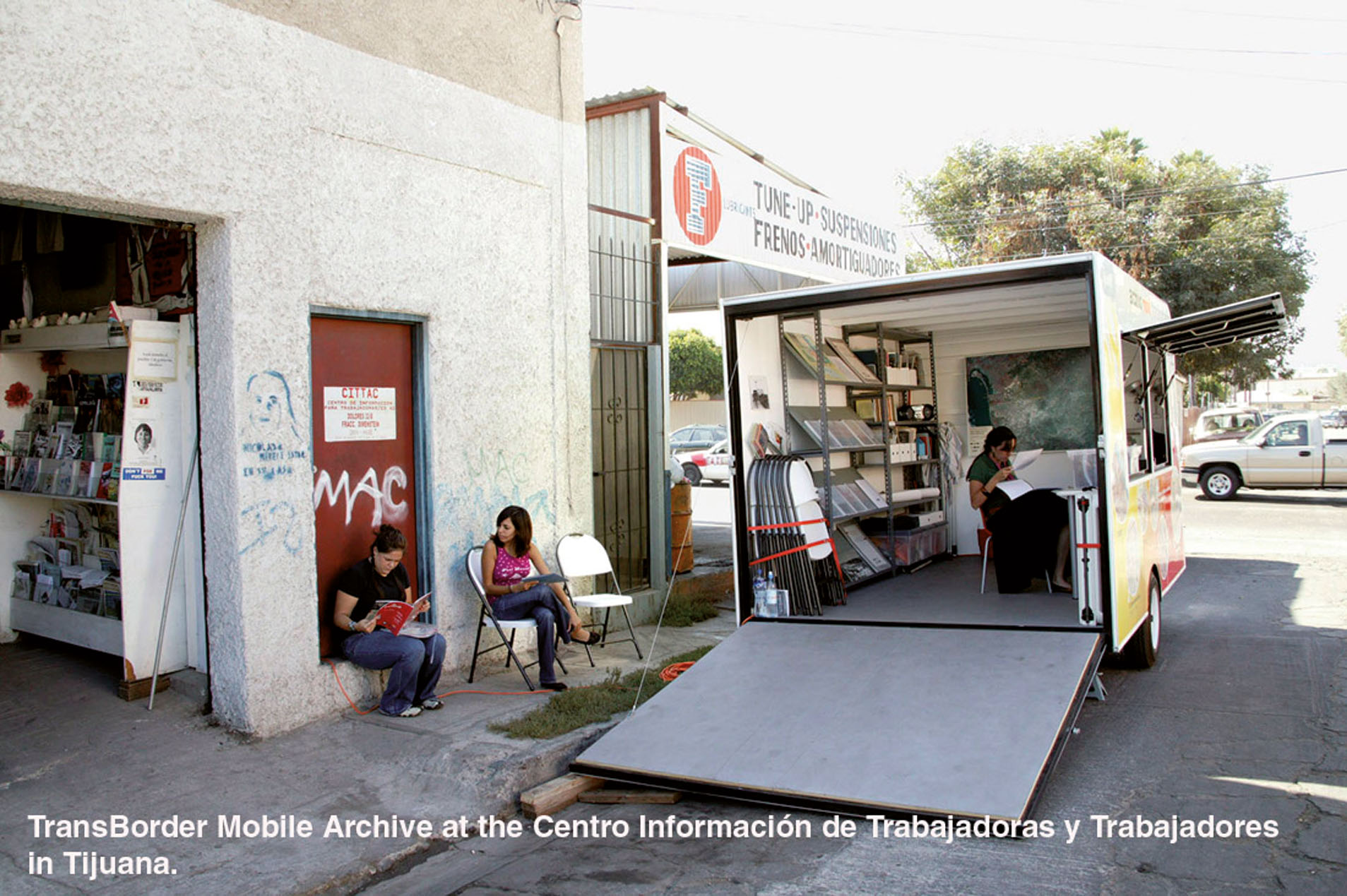
inSite_05 San Diego/Tijuana Transborder Mobile Archive Project, Tijuana, 2005.
Photo : © Fred Lonidier
At this stage, the virtual city has handed its rules and regulations over to the physical city, so the real city watches itself in the mirror and sees its electronic alter ego. However, the virtual world needs its physical places, which are becoming more and more like enclosures than free and open places. If it is true that we live in a post-city age11 11 - See Joshua Meyrowitz, Oltre il senso del luogo. L’impatto dei media elettronici sul comportamento sociale, trans. N. Gabi (Bologna: Baskerville, 1994). in which the concept of territory, intended as a delimited space, is increasingly evanescent, it is also true that the corporeality of architectural territories is hard to demolish or overcome. Given that the model of global connection cannot forgo the corporeality of architecture — Manuel Castells speaks about a city that is globally connected and locally, physically, and socially disconnected12 12 - Quoted in Francesco Moschini, “Roma verso sud,” Anfione e Zeto 24 (2012): 122, n.24. — we can only try to deconstruct the vision of a border intended as a wall by working on a conceptualization of the wall itself as a membrane, that is, as a zone of contact, a multiple and heterotopic boundary, similar to the light edge between the arts. Indeed, the world of art is not a separate and autonomous sphere, defined by an internal matrix; rather, its borders are deformable in order to trigger an unstable equilibrium between different and often opposing forces.
After all, architecture is a controversial art, suspended between the need to build walls, divisions, and enclosures and its vocation for designing spaces in which human beings can feel free, as if walls were not spaces of limitation, but a place of origin.
